Local climate zone classification using a multi-scale, multi-level attention network
 Local climate zone classification using MSMLSA
Abstract
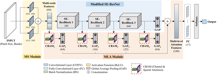
Local Climate Zones (LCZ) offer a climate-aware and standardized classification scheme composed of 17 urban and natural landscape classes. Recent deep learning-based LCZ classification studies have adopted a scene classification approach with computer vision-inspired models. In light of these advancements, this study introduces a multi-scale, multi-level attention network (MSMLA-Net) for deep learning-based LCZ classification. MSMLA-Net integrates a multi-scale (MS) module to generate multi-scale features from the input data and a novel multi-level attention (MLA) module as a branch unit from the model’s main ResNet backbone. MLA uses the convolutional block attention module (CBAM) at multiple stages to generate multi-level spatially and spectrally enhanced features for context aggregation. This study presents comprehensive model-based experiments on model depth, the individual and combined influence of MS and MLA modules, and the addition of attention mechanisms. Furthermore, data-based experiments are conducted to determine optimal Sentinel-2 spectral bands, while OpenStreetMap (OSM) building data, ALOS World 3D DSM height information, and a national land cover map are included as ancillary bands. LCZ classification tests are conducted on six major cities in South Korea. With regards to model-based performance, MSMLA-Net was built using a modified SE-ResNet50 backbone (MSMLA-50) and obtained the best classification results using 48 by 48-pixel input patches with a combination of all Sentinel-2 and ancillary bands, outperforming three state-of-the-art LCZ classification models. In particular, only MSMLA-50 reached over 70% built-up overall accuracy and maintained high accuracy even when tested on completely unseen areas in a “citywise” leave-one-out sampling strategy. For data-based results, the combination of Sentinel-2 Red Edge bands were helpful, mainly due to the greater number of available bands. Training only ancillary data generated up to 75.0% for built-up overall accuracy, albeit at the cost of low natural overall accuracy. Using all available bands and ancillary data produced the best results, but a combination of only OSM and Sentinel-2 bands also generated comparable accuracy. Ultimately, the proposed MSMLA-Net bridges advanced computer vision techniques such as attention mechanisms and multi-level context aggregation to improve LCZ classification. The MS and MLA modules can be applied on different backbones, sophisticated sampling schemes, and data inputs to flexibly achieve improved classification results.
Minho Kim
PhD Candidate
Data-driven, machine learning-based environmental modeling using geospatial data.