Integration of Sentinel-2 Spectral Information with High Spatial Resolution Planetscope Imagery for Wildfire Damage Assessment
 Wildfire damage assessment
Abstract
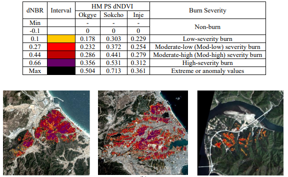
In the short-term aftermath of a wildfire, quick damage assessment is significant to implement efficient disaster response, but the acquisition of reliable reference data can be difficult. Remote sensing (RS) methods using satellite imagery can provide a rapid means to quantify the distribution (burn area) and level of damage (burn severity) for wildfire damage assessment. However, optical satellite images are limited by their spatial and temporal resolutions. In this study, Planetscope (PS) and Sentinel-2 (S2) images were processed to evaluate the Okgye, Sokho, and Inje wildfires in terms of their burned area using differential images of spectral indices. First, Normalized Burn Ratio (NBR) of S2 images and Normalized Vegetation Index (NDVI) of PS images were processed. The correlation between S2 dNBR and PS dNDVI was found to be 0.9390, suggesting the similarity between the two spectral index calculations. Second, to fully utilize the superior spatio-temporal resolution of PS and the broader spectral range of S2, dNBR spectral information from S2 (20 m spatial resolution) was transferred to the high spatial resolution PS dNDVI result (3 m spatial resolution) by histogram matching. The results revealed that this integrated approach classified the burned area of the Okgye wildfire more accurately because the histogram-matched image was able to discriminate smaller features more clearly, such as patches of bare soil and narrow roads. However, this method struggled to estimate burned area for the Sokcho and Inje wildfire study areas due to overestimation in mixed land cover areas and underestimation in mountainous topography, respectively. Although the performance of the histogram matching method can be scene-specific, the intervals from the histogram-matched results can be used as potential benchmarking values for future wildfire damage assessment using VIS-NIR imagery.
Minho Kim
PhD Candidate
Data-driven, machine learning-based environmental modeling using geospatial data.