Histogram Matching of Sentinel-2 Spectral Information to Enhance Planetscope Imagery for Effective Wildfire Damage Assessment
 Wildfire damage assessment
Abstract
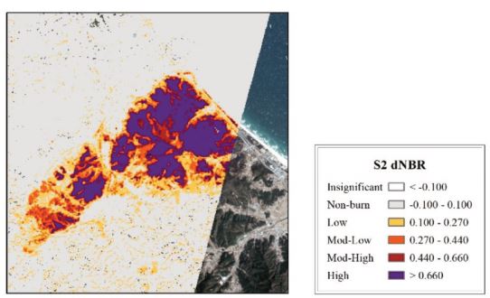
In abrupt fire disturbances, high quality images suitable for wildfire damage assessment can be difficult to acquire. Quantifying wildfire burn area and severity are essential measures for quick short-term disaster response and efficient long-term disaster restoration. Planetscope (PS) imagery offers 3 m spatial and daily temporal resolution, which can overcome the spatio-temporal resolution tradeoff of conventional satellites, albeit at the cost of spectral resolution. This study investigated the potential of augmenting PS imagery by integrating the spectral information from Sentinel-2 (S2) differenced Normalized Burn Ratio (dNBR) to PS differenced Normalized Difference Vegetation Index (dNDVI) using histogram matching,specifically for wildfire burn area and severity assessment of the Okgye wildfire which occurred on April 4th, 2019. Due to the difficulty in acquiring reference data, the results of the study were compared to the wildfire burn area reported by Ministry of the Interior and Safety. The burn area estimates from this study demonstrated that the histogram-matched (HM) PS dNDVI image produced more accurate burn area estimates and more descriptive burn severity intervals in contrast to conventional methods using S2. The HM PS dNDVI image returned an error of only 0.691% whereas the S2 dNDVI and dNBR images overestimated the wildfire burn area by 5.32% and 106%, respectively. These improvements using PS were largely due to the higher spatial resolution, allowing for the detection of sparsely distributed patches of land and narrow roads, which were indistinguishable using S2 dNBR. In addition, the integration of spectral information from S2 in the PS image resolved saturation effects in areas of low and high burn severity.
Minho Kim
PhD Candidate
Data-driven, machine learning-based environmental modeling using geospatial data.