Minho Kim
I’m a PhD candidate in Environmental Planning at UC Berkeley advised by Professors Marta C. Gonzalez and John Radke.
I am a member of HumNet Lab. Currently, I am interested in using GeoAI (computer vision, deep learning, network data science) to model natural hazards and predict
risks in our built and natural environments.
I received my BS and MS degrees in Civil and Environmental Engineering at Seoul National University, where I was advised by Professor Yongil Kim and a member of the SPINS Lab.
Recent News
Highlighted Research
Redefining defensible spaces using spatial responsibility of wildfire mitigation
Developed novel spatial metrics (shared & owed responsibility) to mitigate at individual homeowner scale and built spatial networks to simulate mitigation scenarios in the wildland urban interface. Paper
Fire potential polygons and suppression networks
Hydrology-inspired risk management method to create decision support networks for more effctive, proactive suppression strategies. Paper
Fire spread simulations in synthetic and real landscapes
Comprehensive analysis of a cellular automata fire spread simulator on synthetic and real landscapes in Canada, US, and Chile with optimization to improve simulation accuracy. Paper
Mapping high resolution local climate zones using multi-scale attention models
Developed a novel multi-scale, multi-layer attention model to classify high resolution local climate zones in South Korea using multispectral satellite imagery, building information, and terrain data. Paper
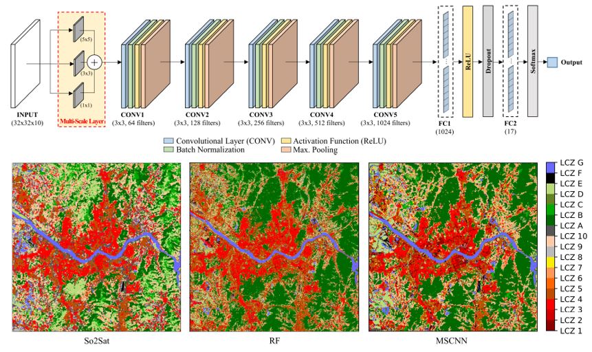
Mapping local climate zones with deep learning
Developed a multi-scale module in a feedforward neural network to map local climate zones in Seoul, South Korea (Presented at NeurIPS 2020: AI4Earth) Paper Presentation
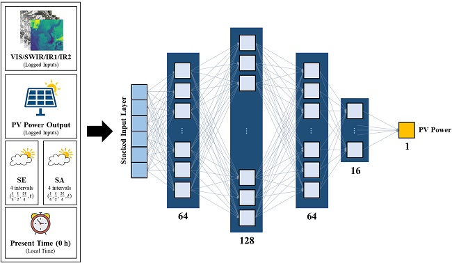
Forecasting solar power using deep learning and geostationary satellite data
Short-term forecast (1 to 3-day ahead) forecast of photovoltaic power using deep learning with COMS and Himawari-8 geostationary satellite images. Paper